Palma – Cabo Formentor
Spectacular route from Palma to Cap Formentor
As per our description of the Mallorca route from Palma to Sa Calobra, there is a well-developed road network on Mallorca, which extends from the capital Palma over the whole island. In other words, the four main arteries are well connecting Palma with all sights of the island. We take advantage of this fact in order to design our routes.If you haven't already done so, we recommend that you book a rental car at Palma Airport.
On above-mentioned route to Sa Calobra, we took the Ma-13 motorway from Palma and then explored the west of Mallorca from Inca to the west coast. Today we choose the Ma-13 again, and drive north to get to know the northern and northeast part of the island.
The Balearic Islands hold many treasures in store for their visitors. No matter which island you choose, you will be amazed. On our todays’ island tour on Mallorca, some spectacular attractions await us.
If you are located in Palma or its surroundings, you would do best renting a car at an airport rental office of Hertz, Thrifty or Dollar brand in Palma de Mallorca. In case that your accommodation is in the northeast of Mallorca, which is a very popular touristic area, you have the option of renting a car in Cala Ratjada or in Can Picafort. By the way, Can Picafort is one of our stops on our today’s route. If you are staying overnight there, you just should do some little adjustments on the route.
The Caves of Campanet and Fonts Ufanes
From Palma, we take the Ma-13 and drive around 45 kilometres north, which is quick, as we are on the motorway, going parallel to the Tramuntana Mountains. Our first stop is at the Caves of Campanet. We will probably get there before 10 a.m. Therefore, it definitively should not be a problem to find a parking slot. The visiting times for these stalactite caves start at 10 a.m. After visiting the caves, our next sight is in walking distance, so we can leave the car parked.
The Caves of Campanet were inaccessible for millions of years and accidently discovered in 1945 in search of water. We do not want to think about the fact that this breath-taking natural wonder almost remained undetected. The underground limestone formations of the rather small cave system are definitely worth a visit; the “Coves de Campanet” are not as crowded as other caves on the island. The cave tour is 400 meters long and takes about 40 minutes. We are sure this visit is a great start of the day...
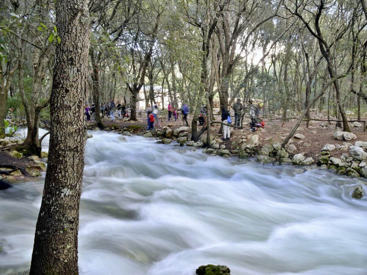
As indicated above, we should leave the car parked at the caves and walk to the Fonts Ufanes. However, it is only worth visiting if these natural water springs are active. The explanation is simple: the hydrogeological phenomenon is only visible when rainwater accumulates in the region's underground aquifer, and overflows after several days of intense rainfall. This is the moment when water gushes out of the ground. In some places, it suddenly rushes up violently into the air in water fountains. In addition, you might see plenty of small streams and rivulets flowing through the forest. All of them go into the Teló stream and finally flow into another bigger stream, the Torrent de Sant Miquel. The peculiarity of these springs is their occasional and spontaneous appearance. You need a little luck to see the Fonts Ufanes. Anyone who has ever witnessed this spectacle will always remember it.
Can Picafort
We drive back towards the Ma-13, cross it, pass through Sa Pobla and after a 20km drive, finally reach Can Picafort via the Ma-3433 and Ma-3410. What to expect in Can Picafort? It is one of the most important tourist areas of Mallorca. There exists a wide range of leisure activities, tourist attractions and services, hotels and aparthotels, as well as pine forests and long sandy beaches... Can Picafort is located in the Bay of Alcudia with 34 kilometres of coastline, where you can find dunes, as well as sandbanks and sandstone quarries. To learn more about the history of Mallorca, you have the chance to visit a prehistoric necropolis (Son Real), or see the machine-gun nests on the beach built by the nationalists during the Spanish Civil War. There are possibilities for every taste. It is up to you how to spend your time in Can Picafort.

The Natural Preserve of S’Albufera
The Natural Preserve of S’Albufera is – with more than 1600 hectares - the largest wetland of the Balearic Islands. We get there following the Ma-12 during 5 kilometres. It is a unique experience to go hiking through the wetland on one of the four existing routes and a good opportunity to learn about the flora and fauna of this coastal region. However, you should keep an eye on the time. The shortest circular route has an estimated duration of 90 minutes. Maybe you decide to do this beautiful excursion another day and therefor plan a whole day for visiting the natural preserve. With sturdy shoes, binoculars and a snack in the backpack. If you drive past the visitor centre, you will get a good overview of the possible routes.

Alcudia and Port Pollença.
We take the Ma-12 for 7 kilometres along the coast until we arrive to Alcudia. Upon entering the walled city, you can immediately feel that a piece of history is still alive here. Since Alcudia’s first documented occupation in the pre-Talayotic and Talayotic times (it is worth visiting the large stone buildings of Son Simó), "half the world" has passed through it. Romans, Vandals, Arabs, Templars (to whom King Jaume I gave a large part of the areas of Alcudia and neighbouring Pollença) and countless corsairs. We say “countless” as Alcudia was completely and utterly at the mercy of pirate attacks. Even the pest and the yellow fever did not stop at Alcudia, although the city was not that affected than other parts of the island thanks to its walls and the possible controls. Similar to the caves of Campanet, we get goose bumps when looking at the city walls. It is different if you just contemplate those city fortifications or if you put yourself in the shoes of the nobles of the 16th century, taking refuge behind the city walls during the revolt of the city guilds (“revolta de les germanies”).
Pollença and Port Pollença, which is only 10 km north of the city following the Ma-2220, have a similar past to the city of Alcudia. Even though the town of Pollença was not properly founded until 1229 under Jaume I, Phoenicians, Egyptians, Carthaginians, Romans, Arabs and many, many pirates had passed through this place before. The fear of attacks among the local population was so big that the coastal region was then only sparsely populated. This is quite comprehensible considering that in the case of an attack it would hit the settlers on the coasts first. It was not until 1829 that the first simple mooring was built in the Bay of Pollença. In 1860, only 10 people lived in the port of Pollença. Today only Port de Pollença - excluding the city of Pollença - has more than 7,000 inhabitants. Go there and think of the first inhabitants of this beautiful bay - quite impressive. Don't you think so?

Viewpoint Es Colomer and Talaia d’Albercutx
You will not get rid of those goose pimples that easily. We now drive to the viewpoint Es Colomer. To get there, you should take the Ma-2200 and the Ma-2210 for 7 kilometres. Once there, please park your rental car and climb the stairs carved out of rock up to the viewing platform. You will have views of Punta Nau on your right hand side. From a dizzying height, we can contemplate 200 meters of cliffs and the roaring sea below. The vastness of the sea and the play of colours in various shades of blue fascinate every visitor. If you have the opportunity to rest at Es Colomer until sunset, you will experience how a red-orange ball slowly pours into the sea and a whole range of colours emerge on the horizon in addition to the blue.
The Talaia d’Albercutx is very close to this impressive viewpoint. It is a coastal defense tower, one of those from which we have spoken in anterior occasions. These defense structures had the purpose - how could it be otherwise - to spot the pirate ships approaching the coast. In comparison to other towers, the Talaia d’Albercutx is a special defense tower, due to its construction at a height of almost 400 meters. If the views from Es Colomer have not already impressed you, you will certainly be wowed here. Think for a moment about the guard up here, all alone, sighting a pirate ship.

Beach and Lighthouse of Formentor
Before getting to the next stop on our route, we have to inform you that the narrow mountain road to the Formentor lighthouse is subject to strict traffic restrictions in the summer as the flow of visitors is overwhelming in the summer months. Nonetheless, there are some good transport alternatives to the lighthouse as the public TIB bus routes and shuttle buses. There are stops near the Es Colomer viewpoint: On Formentor Beach and at Port Pollença. Please check the transport options in advance. Referring to the visit of the beach and the lighthouse of Formentor, there is a paid parking at Playa de Formentor. It is your decision whether you want to try on your own or with a public transport in order to avoid any unpleasant surprise in terms of traffic.
What is there to say about the beach, which by the way has the blue flag award ("Bandera Azul")? Have you ever been at one of those beaches, where the trees - like in a movie - seem to be taking a bath, being that close to the water? Playa Formentor is one of these beaches. A slowly sloping bay with crystal clear water. Anyone visiting the Formentor lighthouse has to stop by here, and vice versa. One cannot be done without the other. It is similar to our other route to Sa Calobra: whoever goes to Sa Calobra must have seen the Torrent de Pareis. It is the same here: Once you are at Playa Formentor, you should definitively also visit the Faro de Formentor. What kind of lighthouse is that? Maybe we can make it understandable with the following anecdote: A few days ago, two colleagues had a conversation about fishing. One of them is a keen angler and he explained to his colleague that the best catch is that of a grouper. The other colleague asked how to recognize a grouper, whereupon the angler replied: “I don't know how to describe it to you, but I can tell you that you will be sure if you catch one. He is the king of fish! ”It is the same with the Formentor lighthouse: We have already seen many lighthouses and integrated them into our routes. This one is different. The reason is similar to the one of Talaia d’Albercutx, which differs from other defenses - located at 400 meters above sea level: Faro de Formentor also stands out among the other lighthouses. Its unique location makes it something special. Look out to sea from there and you will know. It is the king of the lighthouses!

We have reached the end of our route. If you want to add some more impressions to the route and still have time, you could do part of our Sa Calobra route. Instead of driving straight back to Palma, we recommend you a little detour via Pollença, Lluc (to see the mountain monastery there) and the mountain villages of Caimari and Selva in the Tramuntana Mountains. Finally, you will get back to the motorway in direction Palma via Inca.


Canary Islands

Last routes
Los Rodeos (Airport) - Los Gigantes Cliffs
We make it easy for you. And not only that. Truth be told, the first part of your route on Tenerife is going to be SO easy. And comfortable; without narrow serpentine roads (we will add some later on this route, so we won’t end up bored) It’s up to you whether you want to complete this beautiful route within one day or split it up in two days.
We would like to point out that it’s a challenging route if you drive it within one day.
Nevertheless, if you bring with you the energy and happiness for a longer excursion and if you arrive early in the morning on the island, you will enjoy this trip.
After arrival at Tenerife North Los Rodeos Airport, Rent a car on Tenerife with Hertz or Thrifty, if you haven’t already done so, and enjoy your vacation on the island from the first minute on.
The route has a total distance of approximately 170Km. One way. You then have several options for the return journey to the north of the island.
From the airport, we take the TF-24 road and start our tour.
From Arrecife to Timanfaya National Park. Southwest Route on Lanzarote
An island tour by car is great fun. Compared with the other islands of the Canary Archipelago Lanzarote is not too big and can easily be explored by car. The advantages are obvious: short distances and many possible stations to visit.
Today we would like to propose to you an easy and beautiful round trip by car. There are different points of departure. We can start from Arrecife or from Puerto del Carmen which has a wide range of hotel accommodations for travellers. Another option would be to start from the airport directly after your arrival at Lanzarote. The only requirement is to begin the excursion in the morning; without having to get up particularly early.
Assuming that you already got your Rent a Car in Lanzarte Airport with Hertz, Thrifty or with Dollar, we are glad to see that you are ready to explore and experience Lanzarote.
Our southwest route covers a distance of 80 km. The route is even shorter if you start from Puerto del Carmen or from the airport. However, we depart from Arrecife. From there we take the LZ-2 and then drive onto the LZ-501.
La Palma - Roque de los Muchachos (and the sky)
When visiting La Palma, you will immediately notice that you are entering a green paradise. It does not matter which itinerary you choose, you will witness the incomparable lush vegetation that stands out across the island. Laurel forests overgrow the entire island wherever possible: on slopes, in valleys and gorges.
The forests of La Palma are awesome. You should not only admire them with your eyes, but also experience them olfactorily. Smell them!
Above the island opens up a sky, which, thanks to its clarity, creates optimal conditions for astronomical observation. It is not surprising that Roque de los Muchachos houses the best astrophysical observatory in the northern hemisphere.
La Isla Bonita, the beautiful island. This name is justified. Finally, the world biosphere reserve is located on La Palma.
If you are planning a car route on La Palma, you have several options. The road network is star shaped from the capital. Similar to the road network in Mallorca.
For our today’s route, we decided to propose you a north route, along the LP-1. Our way back to Santa Cruz de La Palma we will then take the northeast highway LP-4. In total, we will run around 150 kilometres. That is not a very long stretch. We do not want to highlight any village specially on this route, telling you that this one is more worth visiting than any other is. Each village has its own charm. It is up to you to decide where to stop, and which places attract you most. Nevertheless, as always, there are many sights on our route, which we will propose to you. There is a lot to discover on La Palma.
So take your Rent a Car La Palma Airport at the Hertz or Thrifty counter. When renting the vehicle, it is worth taking a moment to choose the rental car you feel most comfortable with. We will spend a few hours in it. Then we start our route, and drive on the LP-1.